
By Vienna Saccomanno, The Nature Conservancy.
In partnership with: The University of California, Los Angeles, Woods Hole Oceanographic Institution, Greater Farallones Association, Greater Farallones National Marine Sanctuary, Hog Island Oyster Co., and California State University Monterey Bay.
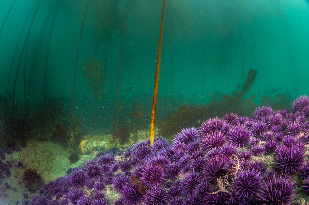
Kelp forests are found along one-quarter of the planet’s coastlines and are critical to maintaining the diversity and resilience of local marine life. Kelp forests, such as the ones that historically dominated the North Coast of California USA, provide habitat and nursery grounds for hundreds of species, support local fisheries, help locally ameliorate ocean acidification, protect coastal communities from storm surge, and have an immense impact on jobs and revenue for the state. But a perfect storm of events beginning in 2013 resulted in the loss of over 95% of kelp forests on California’s North Coast. The combination of a marine heatwave event and the outbreak of a deadly sea star wasting disease epidemic resulted in the local extirpation of the sunflower sea star – a key predator of kelp-grazing sea urchins – and an associated explosion in the purple sea urchin population that contributed to massive losses of kelp.
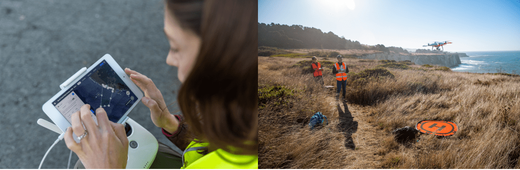
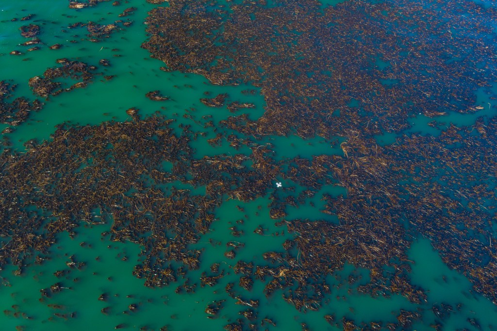
Understanding the spatial and temporal dynamics of kelp loss and recovery is important for implementing strategic restoration and management solutions. Because canopy-forming kelps are distinguishable in aerial imagery when the kelp is emergent on the surface of the ocean, remote sensing is an important tool for documenting changes in canopy area and biomass to meet these data needs. Mapping and monitoring efforts for California’s kelp forests have been historically limited to costly and labor-intensive airplane-based surveys, which have limited coverage in both time and space with the most recent comprehensive survey concluding in 2016. And while satellites such as Landsat can be used to monitor kelp canopy at a larger spatial scale, most satellite data lack the resolution and sensor capability to detect sparse kelp patches, like the ones remaining on the North Coast of California. Local-scale monitoring of emergent kelp canopy dynamics requires remote sensing tools that provide high spatiotemporal resolution such as small unoccupied aerial vehicles (UAVs), also commonly referred to as drones.
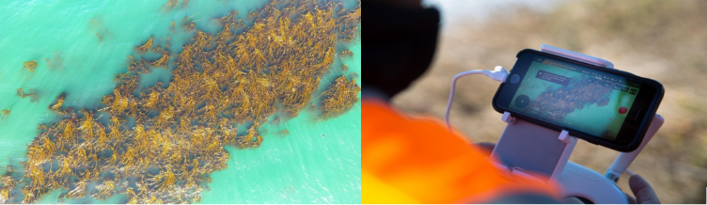
In response to this lack of high-resolution data on remaining kelp, our team comprised of pilots and remote sensing experts from six partner organizations conducted drone surveys at priority kelp forest sites along the North Coast of California in 2019 and 2020 to fill a key data gap for kelp managers and restoration practitioners working at a local scale. These surveys, the two largest marine resource-focused drone surveys conducted in California to our knowledge, are the first very high-resolution assessments of emergent kelp canopy since 2016 for the majority of the priority kelp forest sites along the North Coast and provide documentation of further kelp decline and, in some cases, potential resilience (i.e., recovery after disturbance). We used the drone imagery to create very high-resolution (<1 m) kelp canopy maps that can be used to assess changes in kelp canopy coverage over space and time at a level of spatiotemporal resolution previously unachieved by traditional airplane-based and satellite imagery. We illustrate the impacts of spatial resolution on emergent kelp canopy classification in imagery from both the Landsat satellite sensor and a drone to help practitioners decide which data stream to select from the suite of available remote sensing platforms when asking kelp restoration and management questions at varying scales.
While our drone priority sites primarily contain bull kelp and are located along the North Coast, the methods are applicable for remote sensing of canopy-forming kelp forests with UAVs in other geographies. As global interest in actively restoring kelp forests continues to increase, these results suggest that high spatial resolution emergent kelp canopy data from drones can be used as one essential tool within a larger monitoring toolkit to guide strategic management efforts by informing kelp restoration site and technique selection. For example, in systems where herbivory on kelp is an issue, very high-resolution imagery can illustrate where kelp strongholds are located and therefore guide where techniques such as removing overabundant grazers like purple urchins may be deployed. Furthermore, repeat drone surveys of kelp restoration areas with control sites can allow practitioners to monitor and evaluate the potential efficacy of restoration efforts. The ability to produce very high-resolution data on local-scale spatiotemporal patterns of emergent kelp canopy using drones has the potential to advance strategic kelp restoration and adaptive management on the North Coast of California and around the world.
Read the full paper here.
link when ready.
