
New research detects artificial water points from space, which could support the reintroduction of species to the Sahara such as the Scimitar-horned oryx.
It is widely projected that the Sahara will suffer from the impacts of climate change. In addition, people living in the Sahara are modifying the landscape for agriculture, and oil exploration activities are increasing, often very near to protected areas.
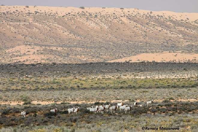
These activities severely impact local biodiversity and many Saharan species are either extinct in the wild or experiencing massive population declines. There is an initiative to reintroduce some species to the Sahara, such as the Scimitar-horned oryx, which is extinct in the wild.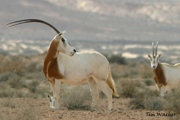
It is believed that climatic changes impacted oryx populations, as they inhabited the region between true desert and the Sahel, an area shrinking as a result of climate change. More recently, the extinction of the oryx is thought to be the result of over hunting and competition with local livestock.
Artificial water points, boreholes where ground water is extracted to supplement livestock, are fairly abundant across the Sahara/Sahel. These features cause widespread landscape degradation for up to 5 km around the water point (see Bing image below) due to the density of livestock that graze around the water point. Furthermore, increases in people and livestock in the vicinity of the artificial water point heighten human-wildlife conflict.
Subsequent selective grazing and concentrated seed dispersal results in significant changes to ecosystem dynamics, and increased exposure and destabilisation of the surface leads to localised desertification. A recent paper, published in the Open Access journal Remote Sensing in Ecology and Conservation, aims to identify where artificial water holes exist and monitor their distribution. This information will improve our understanding of ecosystem dynamics around these features, which will help the long-term success of Scimitar-horned oryx reintroductions.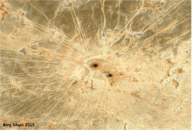
The Sahara is a land of extremes, it is remote, inhospitable and many of its countries suffer from political instability. Satellite-based monitoring offers unique opportunities for monitoring threats to biodiversity because it is low cost, allows frequent revisit time, global coverage and, of course, it doesn’t require field visits.
Researchers developed a method to detect artificial water points from space within the Ouadi Rime Ouadi Achim Faunal Reserve Chad in order to investigate the potential for freely available satellite imagery to provide reliable information about the distribution of artificial water points. Using Landsat 8 data combined with texture analysis the researchers were able to accurately detect artificial landmarks across the heterogeneous environment of the reserve.
75.68% of artificial water points within the site were successfully identified and false positive detection rate was minimal at 7.69%.

The diagram shows the location of successfully identified artificial water points (black: artificial water points that were used to tell the framework what an artificial water point; white with black centre: successfully identified features; asterisks: artificial water points incorrectly identified; white circles: represent features missed by the framework).
The highest densities of artificial water points are towards the south of the reserve as well as to the west. Interestingly, there are almost no artificial water points in the eastern region, an area known to have little pastoralism and human existence, despite the abundance of wadis (seasonally-inundated watercourses).
The study has identified a preferable region to reintroduce Scimitar-horned oryx (highlighted with oryx silhouettes). The methodological framework developed for this work adds to other research attempting to help monitor threats to biodiversity in desert ecosystems, enabling up-to-date information on the level of anthropogenic activities in these habitats to be easily and regularly collected.
The study also showcases how satellite imagery can be used to inform on-the-ground conservation initiatives in an efficient and timely manner, particularly in remote regions where access and the sheer scale of the study site deters research.
