
By Henrike SchulteTobuhne
Let’s go on a quick excursion to the West African savannah! Simply open Google Earth or Google maps (make sure you have satellite view enabled), and gradually zoom in on the part of West Africa where Benin, Burkina Faso and Niger meet. You’ll spot a vaguely sine-wave shape of green standing out from a brighter, yellow-brown background. This is the W-Arly-Pendjari (WAP) complex, the largest contiguous protected area complex in West Africa.
The WAP complex is an ensemble of protected areas, hunting zones and community lands shared by three countries: Benin, Burkina Faso and Niger. It is the most important refuge for West African wildlife, and the stars of the African savannah can all be found here: more than half of all remaining West African elephants and lions, and the last West African cheetah population. But humans thrive here, too — about 1 million people live within 40 km of the WAP’s protected areas.

Back to Google Earth: If you zoom in a bit more, you can see that the WAP complex is surrounded by agricultural fields. In many places, you can trace the boundaries of the protected areas without looking at the official maps. It is inscribed on the landscape by the sudden transition from cropland to natural vegetation.
Both wildlife and the people who live around the WAP depend on it for their wellbeing. West Africa is one of the least developed parts of the world, and most people here depend on either agriculture or pastoralism for their livelihoods. But agriculture means fields, and fields often mean less space for wildlife, especially large species.
From the point of view of large animal conservation, it is important to know if the WAP will be able to provide enough habitat in the future, or whether the savannah is rapidly disappearing. So the question is: Where around the WAP is there agriculture? Has it increased over the last years, and if so, where and at which rates? To answer these questions, you need maps of cropland and natural vegetation in the WAP for many subsequent years. However, the WAP complex covers an area of about 50,000 km2 (the equivalent of half of Iceland), including buffer zones around its protected areas. Clearly, a survey of land cover on foot would be both enormously time consuming and expensive.
This is where Google Earth comes in again. You might notice the time slider function – if you play around with it, you’ll be able to see that for some parts of the WAP, you can track how cropland and natural vegetation changed over the years (see image below). However, for the majority of the WAP, imagery is only available for one or a few years, or not at all – so how can we fill in the gaps?
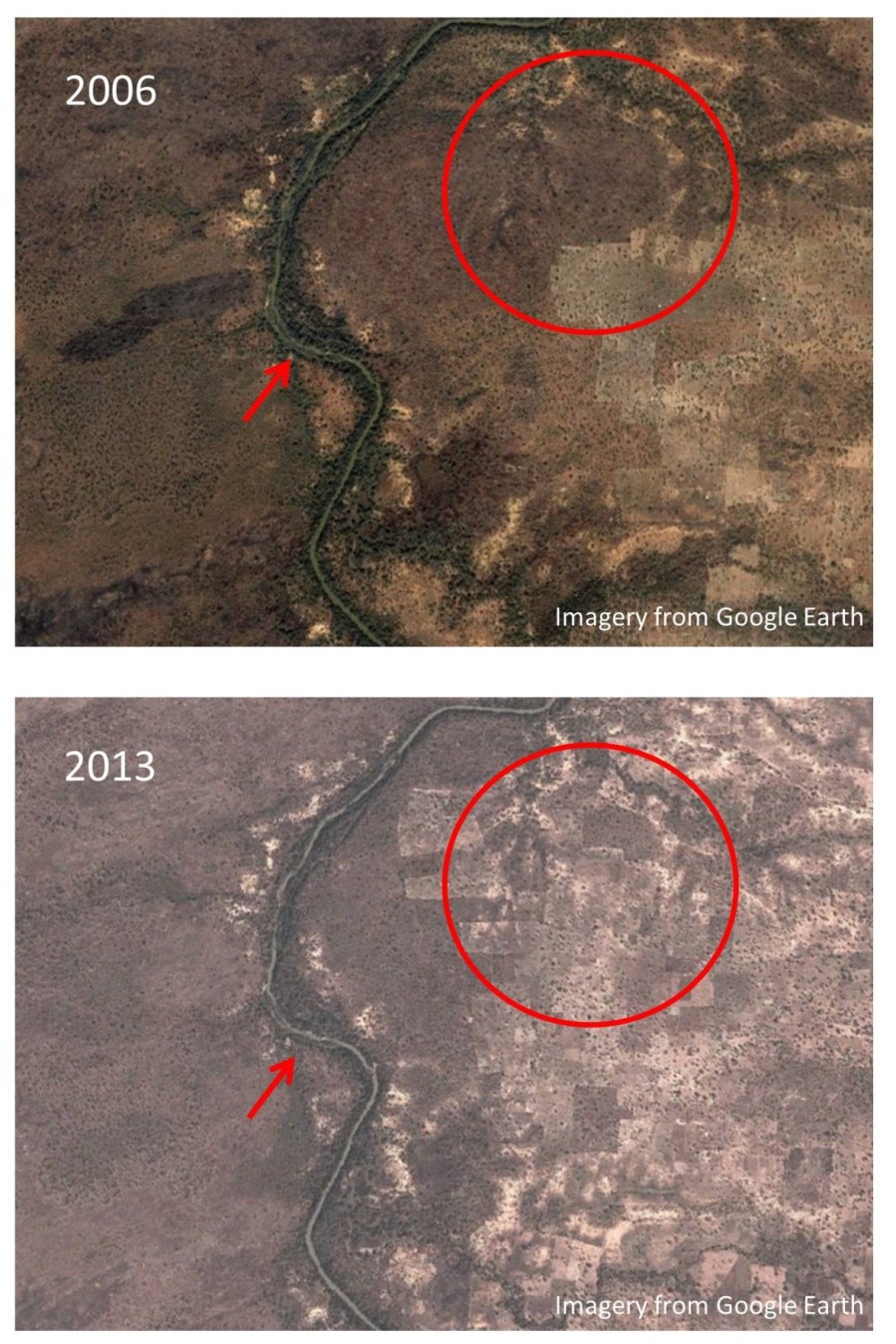
We used the time slider function to “sample” cropland and natural vegetation between 2000 and 2013 across the WAP. This information was then used to map the distribution of these two types of land cover across the years. The basis for these maps was satellite imagery from the Landsat mission, a suite of US satellites that have provided open-access satellite imagery of the entire globe since 1984. Landsat satellites have a relatively coarse resolution (30 m), so it isn’t possible for humans to distinguish cropland from savannah directly from their imagery. However, unlike Google Earth imagery, they provide complete coverage of the WAP complex across all years. In a nutshell, we used the high-resolution, but patchy imagery from Google Earth to train a machine learning algorithm to distinguish cropland from natural vegetation. This algorithm then mapped those two land cover classes onto the coarser, but complete, Landsat imagery.
This allowed us to detect cropland and natural vegetation for the entire WAP across 13 years without leaving our chairs, or spending money on data acquisition (or time travel). As a result, we gained important insights into cropland expansion around this biodiversity hotspot, which are needed to ensure that it will be able to support both humans and wildlife in the future. Crucially, because we only used open-access data, this approach is cheap and easily reproducible, meaning that it can be used to monitor land cover change in areas where both money and field data are scarce. If you’re interested in finding out more about the method, or about cropland expansion in and around the WAP, you can read the full analysis in our paper Protection status and national socio-economic context shape land conversion in and around a key transboundary protected area complex in West Africa
