
by Sophia L. Ellis
Accompanying the paper: Influence of altitude on tropical marine habitat classification using imagery from fixed‐wing, water‐landing UAV s
Tropical marine habitats within a seascape form some of the most productive ecosystems in the coastal zone. They provide important ecosystem services and are particularly vulnerable to climate change. Fine-scale monitoring of these ecosystems, in order to assess their status and quantify changes in spatial extent, is achieved through marine spatial planning. Habitat maps made available through remote sensing technology provide critical information for marine spatial planning purposes.
Technological advances in remote sensing have led to the development of lightweight, unmanned aerial vehicles (UAVs). In our study we deployed a fixed-wing, water-landing UAV to obtain high-resolution aerial imagery of a tropical shallow water environment. We investigated the influence of survey altitude on habitat classification performance and the classification accuracy of thematic maps, in order to help inform UAV-based habitat survey design.
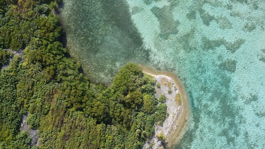
To investigate the influence of survey altitude we conducted repeated UAV flights at three altitudes from two sites on the Turneffe Atoll, Belize. Aerial images taken from the drone survey cameras were geotagged and input into photogrammetric software. This mosaiced the aerial imagery for each survey into an orthomosaic and resulted in the removal of aerial imagery that was significantly distorted or affected by sun glint. Semi-automatic object-based image analysis (OBIA) in analysis software was used to classify the orthomosaics into thematic maps, using machine-learning algorithms. This involved merging pixels to make objects which were then classified into the classes of sea, sand, seagrass, mangrove, coral and N/A, based on the thresholds of image features using an algorithm. The photo-interpretation method produced training samples to train object-based classification and validation samples to calculate the classification accuracy of the thematic maps.
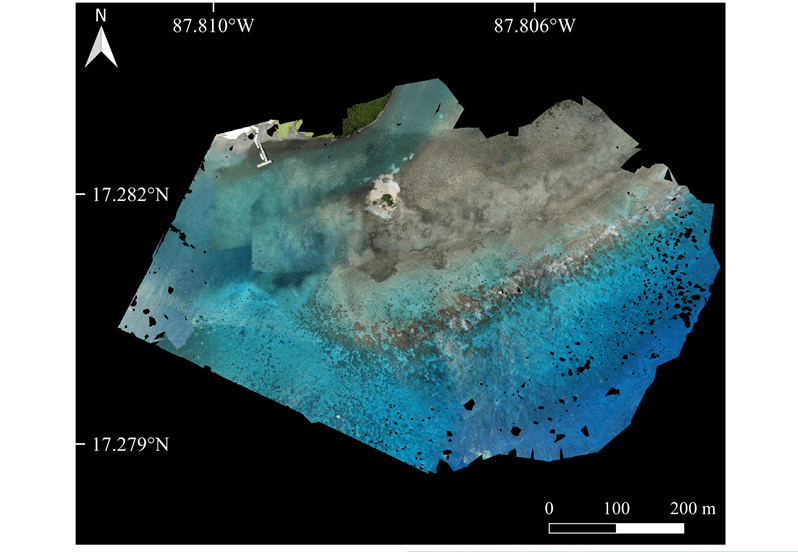
Through our results, we demonstrate the classification accuracy of thematic maps to scale negatively with altitude. A lower altitude gave the highest overall accuracy for thematic maps, and best represented the most habitats in a seascape through a high classification performance. An important consideration from our investigation is that classification performance (KIA) can increase/decrease with an increase in altitude or remain relatively stable, depending on the class. We also found that certain classes showed variability in their classified cover and a level of sensitivity to altitude changes.
Our study quantifies the implications of survey altitude on habitat classification accuracy, thus making our results applicable to other UAV-based studies conducting tropical marine habitat classification. Results are especially relevant to those using fixed-wing UAVs, as we present the ideal survey altitude to be only 5 m above the minimum survey altitude of 70 m recommended for fixed-wing UAV use. Our investigation promotes the use of fixed-wing UAVs for the application of tropical marine habitat classification in remote sensing, as they can produce VHR aerial imagery for developing habitat maps for marine spatial planning purposes. This will be relevant to MPAs, including the Turneffe Atoll, which is designating more preservation zones to increase the percentage of protected waters in Belize.

One thought on “Using a fixed-wing, water-landing UAV to classify tropical marine habitats”